Grid References
Remember that the grid ref defines the bottom left corner of a 100m square in which the feature lives. Many people mark their maps with a dot at the grid ref then draw a circle around it. This effectively puts them out by 50m at the outset.
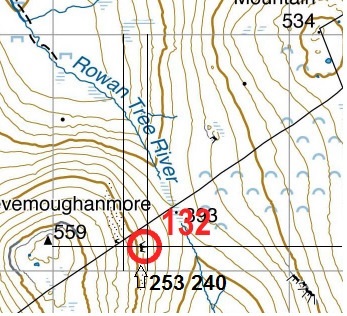
This tricky example from 2013 illustrates:
The 8 figure GPS reference for a crag was 2538 2409 so it just crept into the 6 figure square by a few metres. Anything we checked against the Harvey map on the Garmin came out accurate within 10m (Terry McQueen)
Over or Around
An important decision on a long day out is whether to go over a hill or around it. You can calculate the standard time for either option using Naismith’s Rule but you also need to factor in things such as: the terrain, which muscles are least tired, how good your contouring is etc.
Catchment Features
Look out for catchment features – large obvious features that are easy to hit and will tell you when you are near your target control. You can make fast time to these then slow down and make careful navigation from there onto your Control.
Aim Off
Another good tip around catchment features is to “aim off” – especially with linear features such a wall or river. For example – if you are looking for a stream junction, don’t try to hit it spot on. Instead, deliberately aim below it (say) by a small distance so that you then definitely know to go upstream to get to the junction.